Tourism Services Directory For Buliisa District
Buliisa District is one of the newly created districts, having come into existence by an Act of the Eighth Parliament of Uganda in 2006 when it was curved out of Masindi District. The district started its operations in the Financial Year 2007/2008. The district is located in mid-western Uganda with Pakwach, Nwoya, and Masindi as her neighbor districts in the northwest, northeast, east, and south respectively. The western part of the district on the other hand, is bordered by Lake Albert and the Democratic Republic of Congo.
Much of the district’s 3200sq km lies in the Western Rift Valley floor with the highest point being 1,800 metres above sea level. In addition to the rift valley, the district is home to other physical features such as Bugungu Game Reserve, Murchison Falls National Park and Budongo Forest Reserve. The majority of the population is mainly concentrated along the shores of Lake Albert in the rift valley floor and up the escarpment. The district’s main economic activities are agriculture and fishing. The major agricultural activities in the district are crop production (both food and cash crops) and animal husbandry (especially cattle, goats and sheep) in the rift valley area. Buliisa District is endowed with natural resources such as Budongo Central Forest Reserve, Murchison Falls National Park, Bugungu Game Reserve and Lake Albert among key notable ones. The recent discovery of commercial quantities of oil resources in the district has greatly boosted its economic prospects. It has an all-weather road, connecting it to Masindi and Hoima districts in the south and Nebbi and Amuru districts in the north. It also has ferry services connecting it to West Nile known as WansekoPanyimur Ferry and Para Ferry Services. There are a number of feeder roads being opened by the district local government to link the major economic activities to the markets. Many of the feeder roads, for example Sitini-Kihungya, are narrow, while others are impassable during rainy seasons due to potholes and water-logged spots. The Bagungu are the native inhabitants of Buliisa District, however, there has been continuous migration into the district, not only from the DRC but also (to a lesser extent) from other parts of Uganda and from other neighbouring countries such as Sudan, Rwanda, and Kenya
Bugungu Wildlife Reserve
Located between Masindi and Bulisa Districts the 501sq.Km, the reserve is home to an incredibly wide array of flora and fauna. Numerous mammals including Hippos, Uganda Kobs, Leopards, Lions, Oribis, Buffaloes, Oryxes among other and over 200 bird species. Key activities in the Bugungu include nature walks, game drives, bird watching, camping and picnics, nature walks, visit to the local communities and sigh seeing among others
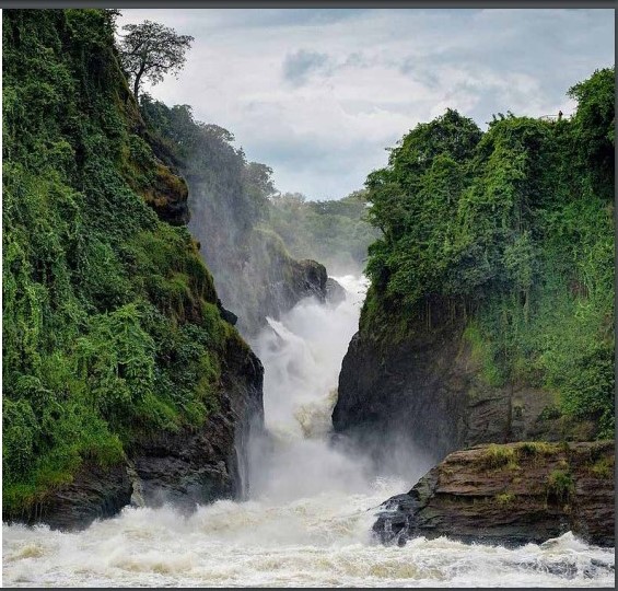
Murchison Falls National Park
Murchison falls National Park Seated on 3,840sqr Km Murchison Falls National Park is one of the biggest and oldest Parks in Uganda. It is named after the mighty Murchison Falls, where the Nile squeezes through an 8m wide gorge creating the most powerful water fall in the world. The park offers an array of activities including boat rides on the Nile and game drives with a wide variety of fauna including, giraffes, lions, elephants, hippos, crocodiles and buffalos among others. Murchison Falls NP is a birders haven with over 400 recorded bird species, Rabongo area is the best spot for lions.
Murchison Falls National Park is best known, though, for the most powerful waterfall in the world. Every second, the equivalent of 200 bathtubs full of water is forced through a gorge less than seven paces wide. The pressure is so great that the ground trembles around it. The water then plummets 43 meters before flowing out toward Lake Albert as a placid river whose banks are dense with hippos, crocodiles, waterbuck and buffaloes. Murchison Falls is just one part of the 384,000-hectare Murchison Falls National Park (MFNP), established in 1952 and now the largest and most-visited national park in Uganda. The Victoria Nile runs through it, its wide, white rapids flanked by riverine forest and rust-red cliffs. Now, the park once again contains over 70 mammal and 450 bird species and an ambitious recovery plan is underway. Large herbivore numbers have doubled in recent years. Three-quarters of all of the world’s Rothschild giraffes live here, and four of the Big 5 (leopards, lions, elephants, buffaloes,) survive. The rare shoebill stork calls MFNP home, along with a unique antelope called the Ugandan kob. Over 600 chimpanzees live in the Budongo Forest, the largest mahogany forest in East Africa. By road-the town is a three-hour drive from Kampala, the capital of Uganda. There are taxis and buses that offer public transport to Hoima. Alternative means such as car are available from Kampala’s tour operators and travel agents. Kabaleega Falls or Top of the falls Commonly known as the top of the falls, this is one of Uganda’s biggest water-falls located in the largest wildlife park in Uganda – The Murchison falls. The water here squeezes itself through a gorge from the source of the Nile in Jinja forcing over 300 cubic meters per second over to Lake Albert on its maiden journey to the Mediterranean Sea. This part of the Murchison Falls national park is also famous with the plane crash of Ernest Hemingway just down the stream in 1954 during the film shooting of the African Queen.
The Albertine Rift Valley
The Western branch of the East African Rift Valley is what divides Uganda from DR Congo, and East African grasslands from the tropical forests of West Africa. The border is marked by the Blue Mountains of the north and the Rwenzoris of the central stretch. The journey through the Albertine Rift Valley, is an impressive one.
The landscape changes from the grasslands and river estuary of Murchison Falls National Park in the north, to the wide plains of Semuliki, then on to the Mountains of the Moon (Rwenzoris) with views of lakes Albert, Edward and George.
The lakes mark the places where plates have moved. Indeed, the whole area is dotted with crater lakes and still experiences periodic earthquakes. The Rift Valley, the flat savannah between the western mountains and the eastern escarpment, is what is described as an ecoregion or biodiversity hotspot and has been recognised by UNESCO as a world bio-sphere reserve.
It supports more vertebrate species than any other part of Africa, including 1061 bird species (half of Africa’s total and including 41 endemic and 25 threatened species) and 402 mammals (34 of which are endemic).
It boasts 175 reptiles, 16 of which are endemic. To reach the Rift Valley use the Fort Portal road through Kasese.
Lake Albert
This is one lake that has had its fair share of renaming. Formerly known as Lake Mwitanzige and Lake Mobutu Sese Seko, is a lake located in Uganda and the Democratic Republic of the Congo.
The origin of the Mwitanzige name comes from the Runyakitara words literally translated as killer of locusts.
This was because of the ancient belief that locusts perished in the lake as they tried to cross it. In 1864, the explorers Samuel Baker and Flóra von Sass renamed it after Prince Albert, consort of Queen Victoria and in the 20th century, Zairian President Mobutu Sese Seko temporarily named the lake after himself after which it reverted to being known as Lake Albert.
It is Africa’s seventh-largest lake, as well as the second biggest of Uganda’s Great Lakes. It is the northernmost of the chain of lakes in the Albertine Rift, the western branch of the East African Rift. It is about 160 kilometres (99 mi) long and 30 kilometres wide, with a maximum depth of 51 metres
(167 ft), and a surface elevation of 619 metres (2,031 ft) above sea level.
Lake Albert is home to many aquatic and semi-aquatic animals such as hippopotamuses, Uganda Kob antelopes, Nile crocodiles, Nile monitors, African softshell turtles, Central African mud turtles, Williams’ mud turtles, various semi-aquatic snakes and various frogs. Water birds are numerous and include pelicans, herons and the rare shoebill.
There are 55 fish species in Lake Albert. Except for Nile crocodiles, the largest predators in the lake are the Nile perch , elongate tigerfish, African tigerfish, marbled lungfish, cornish jack, Bagrus docmak, African sharptooth catfish and vundu catfish.
Others that support important fisheries are Nile tilapia, Niger barb, Albert lates, electric catfish and giraffe catfish that are caught by standard fishing methods and the small Brycinus nurse and Engraulicypris bredoi that mainly are caught by light fishing.
As much as 30 percent of the fish production in Uganda is from Lake Albert.
Recently, Heritage Oil and Tullow Oil announced major oil finds in the Lake Albert basin, with estimates that the multi-billion barrel field will prove to be the largest onshore field found in sub-Saharan Africa for more than twenty years. Semuliki National Park The Semliki Reserve is one of the most beautiful and remote areas in western Uganda.
It is one of the oldest in Uganda, dating back to 1929.
The Reserve stretches from the Rwenzori Mountains to the south up to the southern shore of Lake Albert. To the west are the Blue Mountains of DR Congo, which form the western escarpment of this stretch of the Rift Valley.
To the east is the range of hills which forms the eastern escarpment. The Blue Mountains are quite distant and hazy, but the blue-grey shadowy heights of the Rwenzori mountain range and the escarpment hover above the savannah wherever you look.
To the south, the Reserve is largely golden grassland but it becomes more lush, green and wooded as you approach Lake Albert, for it lies in the valley and delta of the River Semliki (the official border with DR Congo) and its various tributaries.
To reach the Reserve, you leave Fort Portal by the road to Congo.
Once a winding murram road, the road is now a broad four-lane tarmac highway.
Once at Karagutu, at the bottom of the hill, the traveller makes a decision to go either to Bundibugyo, on the border of Congo, via the Semliki National Park and Sempaya Hot Springs.
The park offers activities such as nature walks, primate walks and folklore from the hospitable guide
Budongo Forest Reserve
The forest sits at a medium altitude of 1,100 metres, and the land slopes from southeast to northwest. Budongo Forest Reserve is on the southern edge of Murchison Falls National Park and is famous for its population of chimpanzees. The forest is predominantly filled with swan-forest mixed trees, and a bountiful amount of fruit which the primates pick. Some sections of the forest are savannah and has one of the largest population of mahogany trees, as well as ironwood trees, which the chimpanzees and monkeys use to play. From this forest, you will be able to see Congo’s Blue Mountains, as well as the rift valley escarpment. The ecotourism site runs an environmental education course for local schools, to teach them about their surroundings. The forest has 600-700 chimpanzees, which is the largest number in Uganda. Though the chimps are the main attraction, down by the savannah you can occasionally spot buffaloes and elephants. The morning is the best time to see the wildlife, as several forest inhabitants can be found licking salt by the forest glades. If you are a keen birdwatcher, Budongo Forest Reserve has over 360 species of birds it here that you may see a very rare yellow-footed flycatcher, or an illadopsis puveli, which is a new addition, and not seen anywhere else in East Africa. Just under a 4-hour drive from Kampala, the nearest town to the forest is Masindi, and much of the surrounding area is occupied with houses, schools, and markets. It is best to visit during the dry season, which is between December and February, and again from June to September. Temperatures are consistent throughout the year, hovering between 19-32 °C.
Budongo Forest Located three hours from Kampala Budongo is an ideal addition to the Murchison Falls itinerary. The major site in Budongo Forest is the Kaniyo Pabidi Ecotourism site, Busingiro Ecotourism site are located along the boundaries with MFNP. Key activities in Budongo Forest include Chimp tracking and birding along the royal mile running from Nyabyeya Forestry College to the research station. The forest boasts of more than 360 bird species, 290 butterfly species, 130 butterfly species, 465 tree species, as well as 24 mammals of which nine are primates
Busingiro Eco-Tourism Site
The site is located in Buliisa District, Western Uganda 41 kms west of Masindi on the Butiaba Road. It is found in Budongo Mahogany Forest. This place was used by King Kabalega as his ‘Busingiro’ (relaxation place) and is about three to four-hours drive from Kampala City. The site is part of the Budongo Forest Ecotourism Project established in 1992 by the Uganda Forest Department with the aims of conserving the forest by working closely with the forest edge communities. The project provides local employment; encourages sustainable income generation from the forest for local communities; and runs a Conservation Education Programme. The site is found in Budongo Forest, the largest Mahogany forest in East Africa, where trees grow up to 80 meters. Some parts of the forest are covered by and grassland. The site is a habitat for several primate species including chimpanzees, baboons, monkeys. small mammals, reptiles, birds, butterflies. It has various tree species including mahogany, fig trees, iron wood and stranglers. The site has the Royal Mile which is a stretch of one mile with a collection of all tree species found in Budongo Forest Reserve.
Compiled by:
Kusiima Wilson
INFORMATION TECHNOLOGY OFFICER
BULIISA DISTRICT LOCAL GOVERNMENT